Commercial Satellite Imaging Market to Hit USD 19.15 Billion by 2035, Driven by Rising Demand for High-Resolution Earth Observation Data | Research by SNS Insider

The Commercial Satellite Imaging Market is expanding due to increasing demand for geospatial intelligence, environmental monitoring, and AI-driven analytics, with the U.S. market growing from USD 2.15 billion in 2025 to USD 7.21 billion by 2035.
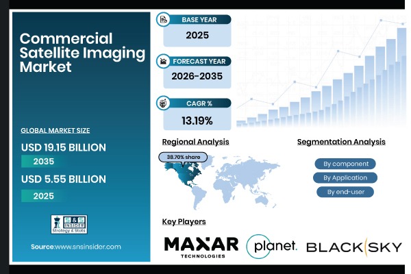
Austin, March 05, 2026 (GLOBE NEWSWIRE) — The Commercial Satellite Imaging Market size was valued at USD 5.55 billion in 2025 and is expected to reach USD 19.15 billion by 2035, growing at a CAGR of 13.19% over 2026-2035. The growth of the market is driven by increasing defense expenditures, the proliferation of small satellite constellations, and technological advancements in sensor technology.
Download PDF Sample of Commercial Satellite Imaging Market @ https://www.snsinsider.com/sample-request/7782
The U.S. Commercial Satellite Imaging Market is estimated at USD 2.15 billion in 2025 and is expected to reach USD 7.21 billion by 2035, growing at a CAGR of 12.88% from 2026-2035. Due to its significant defense and intelligence expenditures, well-established Earth observation programs like those from the NGA and NRO, and a sophisticated space industrial base, the U.S. is the greatest market for commercial satellite imaging.
Segmentation Analysis:
By Component
The hardware segment accounted for the highest revenue share of approximately 54.15% in 2025, owing to the high capital expenditure associated with satellite manufacturing, sensor development, and launch vehicle integration, and strong demand for advanced optical and SAR payloads. The services segment is anticipated to achieve the highest CAGR of nearly 14.02% during the 2026–2035 period, driven by the increasing demand for value-added data analytics globally.
By Application
By 2025, the defense & intelligence segment contributed the largest revenue share of 38.25% due to its critical role in mission planning, surveillance, reconnaissance, and treaty verification. The disaster management segment is projected to grow at the highest CAGR of about 14.85% between 2026 and 2035 due to the increasing frequency and severity of natural calamities.
By End-User
The government accounted for the largest share of the commercial satellite imaging market with about 36.50% in 2025, owing to their direct responsibility for national security globally. In addition, it is slated to grow at the fastest rate with a CAGR of around 13.95% throughout the forecast period of 2026–2035, as federal, state, and local agencies seek comprehensive geospatial data platforms, climate change assessment tools, and smart city development capabilities.
If You Need Any Customization on Commercial Satellite Imaging Market Report, Inquire Now @ https://www.snsinsider.com/enquiry/7782
Regional Insights:
Asia Pacific is the fastest-growing segment in the commercial satellite imaging market with a CAGR of 14.80%, as the awareness about geospatial intelligence, government investments in Earth observation programs, and space infrastructure modernization in developing nations is growing.
North America held the largest revenue share of over 38.70% in 2025 of the commercial satellite imaging market due to an established space industrial base, stringent requirements for geospatial intelligence, and high defense spending on space technologies.
Escalating Defense Expenditures and Geopolitical Tensions to Drive Market Growth Globally
The requirement for ongoing surveillance, intelligence collection, and strategic reconnaissance is the primary driver of the commercial satellite imaging market share rise, along with rising defense spending and geopolitical tensions. The market’s foundation, the uptake of high-resolution optical and radar imaging, and the global market share are all being driven by these national security and real-time threat monitoring solutions.
Key Players:
- Maxar Technologies
- Airbus Defence & Space
- Planet Labs PBC
- BlackSky Global
- Satellogic
- Capella Space
- Iceye
- L3Harris Technologies, Inc.
- Lockheed Martin Corporation
- Northrop Grumman Corporation
- Thales Alenia Space
- Boeing Defense, Space & Security
- Spire Global
- Leonardo S.p.A.
- Imagesat International (I.S.I) Ltd.
- Telespazio (Leonardo/Thales)
- European Space Imaging (EUSI) GmbH
- GHGSat Inc.
- SpaceKnow Inc.
- Galileo Group, Inc.
Recent Developments:
In January 2025, Maxar Intelligence released first images from its WorldView Legion satellites, demonstrating significant advancement in 30 cm-class very high-resolution imaging capabilities for government and commercial customers.
In June 2024, Airbus announced the construction of its latest geostationary satellite, delivering enhanced capabilities for meteorological and environmental monitoring across Europe and Africa.
Buy Full Research Report on Commercial Satellite Imaging Market 2026-2035 @ https://www.snsinsider.com/checkout/7782
Exclusive Sections of the Report (The USPs):
- PRICE TREND & REVENUE MODEL ANALYSIS – helps you evaluate ASP trends for very high-resolution optical imagery, subscription versus tasking versus archive pricing models, SAR democratization impact on price compression, and long-term price forecasts through 2032.
- CONSTELLATION CAPACITY & SUPPLY EXPANSION METRICS – helps you analyze growth in active commercial imaging satellites by resolution band, annual launch volume across optical and SAR platforms, data downlink and ground station expansion, and tasking turnaround time benchmarks.
- TRADE FLOW & GEOPOLITICAL RISK INDEX – helps you assess cross-border data licensing revenue flows, export control and shutter control policies across major regions, tariff impacts on satellite component manufacturing, and shifting supply dependencies among global operators.
- INVESTMENT & INNOVATION INTENSITY TRACKER – helps you measure R&D spending as a percentage of revenue, patent activity in AI-driven climate modeling and geospatial analytics, venture capital funding trends in space imaging startups, and innovation outlook across hyperspectral and edge-processing technologies.
- REGULATORY & STANDARDS COMPLIANCE LANDSCAPE – helps you track ITU frequency allocation compliance rates, regulatory demand drivers linked to public geospatial initiatives, and evolving data format and interoperability standards impacting satellite imaging manufacturers.
About Us:
SNS Insider is one of the leading market research and consulting agencies that dominates the market research industry globally. Our company’s aim is to give clients the knowledge they require in order to function in changing circumstances. In order to give you current, accurate market data, consumer insights, and opinions so that you can make decisions with confidence, we employ a variety of techniques, including surveys, video talks, and focus groups around the world.
CONTACT: Rohan Jadhav - Principal Consultant
Phone: +1-315 636 4242 (US) | +44- 20 3290 5010 (UK)
 Disclaimer: The above press release comes to you under an arrangement with GlobeNewswire. IndiaEveningPost.com takes no editorial responsibility for the same.